Showing posts with label Maps. Show all posts

Thursday, July 16, 2015

Travel and World Geography Fun


This summer we decided to have a themed week where we studied different concepts about world travel.  My children love to look at maps, as I did as a child. I think many children do.  It is part of building spacial awareness. 

I am definitely interested in other cultures.  Part of that comes from my experience living over seas when I was a child.  We moved to the UAE when I was 6 and stayed until I was 12. We took many school field trips were to learn about the culture. I wish my children could experience the markets, architecture, and just way of life. I hope to expose them to other cultures in various ways at home.

There seemed to be a plethora of activities we could have done this week. Lots of great ideas on Pinterest! Being in my 3rd trimester of pregnancy, I tried to pick activities that were fun, but simple!  Here are some of the things we did. 

Learning About Passports

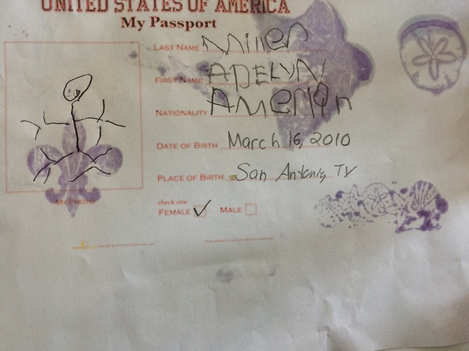
We made our own passports and took trips to many countries around the world! I used picture cards of famous places to visit around the world to choose our destination.

Our airplane was very simple.  We put a few chairs together and then brought a small bag for luggage along with our home made passports.  One of us sat at the desk while the other waited in line to have their passport stamped. We pulled out my stamps and ink pads. The kids now understand that they cannot get into another country without it. 

Adelyn going through customs and getting her passport stamped by Zachary.

Zachary stamping passports. 


I am being approved by Adelyn.


Play Doh Structures

We took out our Play Doh and chose a structure from the cards to make.


Zac made the Alamo. I cannot get it to upload correctly.


Adelyn making her pyramid.


Flying to Bed

Each night my husband likes to fly the kids to their beds. This week they expanded their process by waiting for Scott at the "airport," selecting a few places to go from our map, and then having Scott fly them to those places on their way to bed. Sometimes they pick other countries, US cities, planets, or fictional places.  This week they chose countries!

Zachary is going to Italy

Scott is confirming a location chosen by one of the kids and showing them where it is on the map.

Learning the 7 Continents Song

Check out our movement activity for learning the 7 continents in song here!


Monday, January 13, 2014

A Continents Song with Spatial Awareness


As a second grader, I remember really enjoying the unit when we studied the continents.  Zachary has been interested in the continents since my brother n law taught him a song about the continents when he was 3. Adelyn is now 3 and she is acquiring her own interest in maps so we pulled out the large world map and taught her the song (thank you again Kev!)

Both of the kids had a great time jumping from continent to continent as each one was called out during the song.

This activity is great for:


  • spatial awareness
  • sensorimotor
  • auditory skills
  • visual skills


Wednesday, August 14, 2013

Maps for Kids on the Road


Image from Google Maps.  Thanks Google!

Welcome back to the blog!  I've been off for the summer.  I went on a kind of "obligation vacation" of the sort (with the exception of parenting).  I got to have a break from music therapy work, choir, teaching faith formation, scheduled sports and as you can see, I have not taken the time to post either. These are all things I love but the break this summer was very needed.  School is beginning in two weeks and I could have gone two more plus that as far as school starting again but it's coming so here I am getting back into the swing. 

We are about to take our last trip for the summer. It will be a long weekend trip up to Amarillo and Lubbock where my parent-in-laws live as well as some cousins of Scott's family.  We do not travel up there often so we are very excited.  Especially the kids!  But of course...the drive will be long and kids will be asking, "Are we there yet?" or "when can we go to the bathroom?" as I DEFINITELY did when I was a kid. 

Back in the spring ,NPR's Talk of the Nation, had a show on maps.  I found it fascinating and one of the callers shared what she does in the car for her kids to help them continue to develop spacial awareness skills. She gives one or two kids a map to look at while driving and the other might get the GPS.  

To get a better idea, spatial awareness is the ability to be aware of oneself in space or organized knowledge of objects in relation to oneself in that give space (http://occupationaltherapyforchildren.over-blog.com.).    Spatial awareness visualize patterns in space especially in depth and distance (Ehow.com.) Spatial awareness can also transfer to many other skill areas especially in relating to structure, organization, how you visually picture things in your mind and is an important factor in our overall perception.  

I thought back to how much I LOVED looking at maps as a kid.  I used to stare endlessly at a giant and detailed map of Louisiana in the Dairy Queen my grandpa owned when I would go to work with him.  Honestly I still love to look at maps. 

 I thought that having maps for my kids during our upcoming drive would be more fun for my kids as well.  They can stay a little more occupied AND  learn to figure out when the next bathroom stop will be.  Well... it maybe a few more years before we reach that one.

Map Actitvity

  1. I printed off a large map of Texas with the basic rout (as seen above.)  
  2. I also printed out more detailed maps of different sections of the route. 
  3. I then also printed an even more specific one of Amarillo so they can see individual streets when we get close.  Of course they may be fast a sleep by the time we arrive but you NEVER know!!


I hope this is something that others find enjoyable and also helpful.  

Thursday, June 2, 2011

Maps and World Structures

Books

Music
  • The Continent Song- Tim Pacific from www.Songsforteaching.com
  • The 50 States and Captials Song- Tim Pacific
Crafts
  • USA map coloring- color and place stickers on all of the places you have visited
  • World map coloring
  • 7 Continents Mobile- Picture of the world at the top with each of the 7 continents hanging from each other. On the back of each continent glue a picture of a famous world structure that can be found there.
Activities
  • Study a map of the state and write a letter for each major city. Observe all of the places you have been to.
Baking
  • Pick a country, state or city and make some ethnic foods.
We used this world map to color. It came from google images.

We used this map to color and label all of the places we've been. This one also came from google images.

We cropped the pictures below to be the same size in Microsoft Word and glued them together. The other continent pictures hung from the world.

Blog Archive